Local News
Proposed college residence draws concerns from neighbourhood
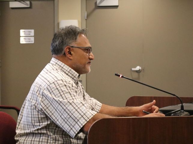
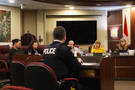
A proposed residence for Great Plains College in Swift Current has received some pushback from its surrounding neighbourhood. Swift Current city council held a public hearing on Monday night regarding the college's request for discretionary use at 45 Sidney Street East for a 12-unit student dorm. Five residents and property owners within a 75-metre radius contacted the City to voice concerns about the development, with two of them against it and one in favour. All five correspondences to the City cited weekday daytime parking issues that already exist along Sidney Street East and 1st Avenue Northeast. "There's not enough parking for them," wrote one nearby resident. "We already have problems with Stark & Marsh. Parking is already at a premium in our neighbourhood. We come home with groceries to park in front of our home and find somebody else already parked in front of our house. We then have to park our vehicle in front of someone elses house to carry in our groceries at a greater distance. With having a partial disability, this causes additional and unnecessary pain. It also causes stress to us." Four parking spots on the east side of the building currently exist for potential residents according to the college. Forty-four more parking spots, owned by the college, are across Memorial Park just north of the Royal Canadian Legion Branch 56. "Other businesses don't have that, yet we can offer that to our students that live there," Vim Parmar, manager of infrastructure, planning, and projects for Great Plains College said at the public hearing. "If they stay on the street too long, the City can, by all means, make it a two-hour parking (limit on Sidney Street) or whatever they need to address that issue, but from where we stand, the college is addressing the issues of parking very well." A localized drug issue was brought up in one of the letters quite extensively. The resident claimed a home on Central North Avenue is well-known by RCMP for selling and creating methamphetamine. A five-unit home to the south has also allegedly been involved in drug activity in the past. "There is a serious drug problem in our neighbourhood with the selling and use of meth and pot," said one of the submissions. "We feel that having a boarding house would add to that problem. The students could easily be approached to purchase drugs or sell." The college was quick to offer a rebuttal on this claim, citing their students will be focusing on their futures, not illegal activities. "We're going to be attracting students that want to further their education so we're going to bring in quality people that want to see themselves move forward here," Parmar said. A letter, from a resident in a duplex next door, wondered if their property value would decrease and if the potential re-zoning would affect property taxes in the neighbourhood. Parmar said he'd already had dialogue with the City who assured him property taxes wouldn't change. "I think from what I've heard from some of the comments here tonight about the neighbourhood, our college dorm will be bringing something more advantageous to the neighbourhood," he said. "We're bringing in students that are here to study and further their education. I think that will add to what's happening in the neighbourhood, not take away from it." Other issues included by residents ranged from partying, the alleyway between Central Avenue North and 1st Avenue Northeast on the 400 block already being in disrepair and increased traffic would amplify it, and poor lighting in the alleyway inviting people to search through cars and backyards. The public hearing was one of three steps the city council is required to perform when considering a discretionary use application. Notifying homeowners within a 75-metre radius of the proposed development, and advertising it in the Southwest Booster, and on the City's site was one step already completed. The other step is to allow the planning division to review the suitability of the development. City council will make its decision at the August 19 meeting.